
["Everyone who’s been to Nepal Himalayas are big. But nobody prepared me for the reality of breathing hard at altitudes already near those of some Rocky Mountain Rockies above me" and,
"Many walks lay claim to the title of World’s Greatest Trek — the Milford Track in New Zealand, Mount Kilimanjaro in Tanzania and the Inca Trail in Peru are a few. But none of those are epics through valleys surrounded by five-mile-high peaks, staying every night in teahouses run by local villagers and stocked with good kitchens, cold beer and Snickers bars. The Annapurna Circuit marries natural grandeur, cultural immersion and relative luxury in a union found nowhere else" writes ETHAN TODRAS-WHITEHILL in his LAST FOOTFALL IN NEPA

Just over a third of the way through the legendary 150-mile Annapurna Circuit trek, circling the Annapurna massif in Nepal, I have finally reached a height where no smaller mountains obscure my sightlines to the peaks. Ahead, four days on, lies Thorong La, a daunting 17,769-foot pass, the high point
Everyone who’s been to Nepal Himalayas are big. But nobody prepared me for the reality of breathing hard at altitudes already near those of some Rocky Mountain Rockies above me.
If my fiancée, Jen, and I had driven this same route in a jeep, my memories now and forever after would be a blur of trees and far-off villages, the mountains beautiful but remote, hardly more vivid than those seen in nature documentaries or computer wallpaper. Instead, as we approach the base of Annapurna III after a week of walking, my head is swimming with images seen close up: swaying footbridges over thunderous gorges; rocky footpaths jammed with goats, donkeys and water buffalo; terraced rice paddies thrusting green shoots against the olive hillsides; narrow stone Gurung villages filled with shrieking children, chatty shopkeepers and the low hum of chanting monks seeping out of brightly colored Buddhist monasteries.
And the mountains. Day by day, we’ve hiked in the company of the Annapurnas, admiring them from a distance in their shifting costumes of sun and shadow, sighing each time they hid behind clouds and cheering when they emerged. They feel like our mountains, our friends. Our Annapurnas.
It is a shame, then, that by 2012 a road will have been built on this path, destroying this experience and, according to many, placing the last nail in the coffin of what was once the greatest trek on earth.

Many walks lay claim to the title of World’s Greatest Trek — the Milford Track in New Zealand, Mount Kilimanjaro in Tanzania and the Inca Trail in Peru are a few. But none of those are epics through valleys surrounded by five-mile-high peaks, staying every night in teahouses run by local villagers and stocked with good kitchens, cold beer and Snickers bars. The Annapurna Circuit marries natural grandeur, cultural immersion and relative luxury in a union found nowhere else.
The circuit is a tale of two river valleys: up the steep, lush Marsyangdi, then over the pass and down the wide, arid Kali Gandaki. But in recent years a road, usable by buses and four-wheel-drive jeep-like vehicles, was completed that runs up the Kali Gandaki to the base of the pass. On that side, most trekkers now opt to ride in the jeeps rather than walk in their dust, and as a result, the time needed to complete the circuit has shrunk from 17 days to 11. In the coming years, with the road now being built on the Marsyangdi side, the undeveloped portion of the trek will shrink again, to just four days.
Roads are the bane of trekkers, most of whom — myself included — want to visit places where only their own two feet can take them. On trekking blogs and message boards, purists are already mourning Annapurna ’s demise. So when I walked the Annapurna Circuit this past October, I decided to test this trekking prejudice: with Jen, a guide and a porter, I would walk the 17-day trail, even if it meant mingling with jeeps, and find out first-hand if all the doomsaying was warranted.
Thorong La is the highest altitude reached by many trekkers in their lifetimes, a few hundred feet higher than Everest Base Camp and eclipsed on the popular-treks list only by Kilimanjaro’s 19,331 feet. October, after the usual monsoon months, is prime trekking season because it is typically the driest month.
For pretty much every trekker in Nepal Annapurna , Everest or any of the other fabulously scenic regions, the preparation starts in the Thamel neighborhood of Katmandu
Then the bus ride from Katmandu Bhulbhule
The first day started out misty and wet, and although I was excited when after 13 miles our guide announced that the night’s teahouse was around the corner, I was anticipating a bowl of rice and lentils for dinner and a dung-burning hovel in which to sleep. A couple of decades ago, when enterprising Nepalese villagers had only recently begun offering tea and space on the floor to passing hikers — giving rise to the term “teahouse trekking” — I might have been right. But since 1993, over 60,000 people on average have visited the Annapurna region every year, drastically altering the hospitality landscape.
OUR stop that night, the Waterfall View Guesthouse, was a two-story pink and aquamarine motel-like structure and restaurant overlooking a lofty cataract. The double rooms had foam mattresses, pillows and electricity, and the four-page restaurant menu included fresh-baked bread and imported beer. For hikers accustomed to dehydrated meals and wet tents, it was almost too much. I stuffed myself with vegetable lo mein and an Indian potato curry, washed down with Nepali masala milk tea.
The next day the trail began to climb, and we passed pairs of middle-aged trekkers, dropping them one by one with our younger legs. Soon huge masses of schist, granite and sandstone rose on either side of us, daubed with green moss and brown lichen and dripping with cascades of black fungus that grow in the runoff of the monsoon rains. It was as if Jackson Pollock had been given an entire mountainside as his canvas.
That night, it began to rain in earnest. A drenched, forgettable next day took us to Chame, the largest town this side of the pass. We were happy to hang our clothes and dry our boots by the Shangri-La Guesthouse’s stove, which the proprietor finally lighted after much prompting. It poured all that night, too, and with the other guests, we stayed on the following day, passing the time and hoping the driving downpour would stop. It is precisely to avoid rains like this, supposedly rare in the fall, that nearly three times as many people walk the trail in October as in the summer monsoon season. We had caught the anomaly.

The next morning the sun returned and luckily did not desert us for the rest of the trip; we needed every minute of it to melt the snows that the storm had deposited higher up. Leaving Chame, we caught our first glimpses of Annapurna II and IV, then Annapurna III the next day (the peaks are numbered by height, not placement in the range), gasping each time at the angle at which we had to hold our heads to view them. But the trickle of trekkers heading the opposite way, retracing their route after giving up on making it over Thorong La, soon grew to a stream, keeping us sober-minded with their snow reports. “Chest-deep on the pass — no one’s crossing,” a lone Israeli said. “Knee-high in Manang,” a British couple announced.
The sun did its work, and when we arrived two days later in Manang, a landmark town on the trek, the snow there had largely melted. Most trekkers stay over an extra day in Manang, partly because at 11,600 feet it’s at the perfect height for acclimatizing, but mostly because at the head of a valley crowned with several heart-stopping peaks, it’s a simply perfect place to be. If Manang were in Colorado Montana
Hundreds of trekkers were in town, backed up from waiting out the rain and snow, running into fellow travelers they had met at other points on the trail. Most of the crowd had soon coalesced into groups, newly formed clans of six to eight united by age, language or sheer happenstance. Jen and I found ourselves splitting thermoses of tea and playing cards with four Australian professionals, a South African management consultant and a Canadian occupational therapist (the only woman among them), all in their early to mid 30s.
Although we would recognize it only afterward, the laughs and the fledgling nicknames — the sense of everyone banding together against the cold, fatigue and thinning air — were as great a joy during our time in the Marsyangdi River Valley
Before leaving Manang, we stopped in for the afternoon lecture at the Himalayan Rescue Association, staffed that season by volunteers from Bozeman , Mont.
After Manang, our new group of eight trekkers (with three guides jostling for primacy) slept one night at 13,000 feet and another at 14,500 at the base of Thorong La, walking only two or three hours a day to follow the Bozeman doctor’s advice. Two of the Australians were already suffering a little, taking each step as though slogging through a bog of molasses. The drifts on the pass were still high, but by the time we arrived, people had been going over for a day or two, packing the snow into a path with each bootfall.
Crossing Thorong La was by far the hardest day of the trip: a 3,200-foot climb to the summit, followed by a 5,200-foot descent to the Hindu and Buddhist pilgrimage site of Muktinath on the other side. Everything over 15,000 feet was covered in snow and ice. We rose at 3:30 a.m. , intending to reach Muktinath before a powerful wind began blowing up the valley there as it does every afternoon. It was so cold my Camelbak hose — the hiker’s lifeline for water — froze within 10 minutes as the lights of our teahouse faded to black below.
But Jen and I, both under 30, were fit and had been close to these heights before, and as the predawn light hit the snowscape, we realized that our worries about altitude sickness and the impassable snows had been needless. We said hello to Annapurna III as it reappeared after days of hiding, now far off, and stopped for a hot lemonade at one of the three teahouses we were shocked to encounter above 15,000 feet.
At 18,000 feet, the air holds half the oxygen it does at sea level, a phenomenon I learned the hard way as we tried to pass frustratingly slow trekkers in the deep snow. The effort so drained me that for the last 500 vertical feet I became one of them, Jen impatiently dragging me upward and stuffing energy bars into my mouth.
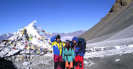
We reached the pass at 7:30 , too tired to jump with the joy we felt. After a half-hour of taking the obligatory snaps with the pass marker and prayer flags, verifying the altitude on a GPS and catching our breath, we headed down. Boot-skiing, butt-sledding and mud-running, we made it into Muktinath around lunchtime. The whole day of trekking was only seven and a half miles, but it had taken us over nine hours. (The molasses-boggy Australians did it in 12.)
Feeling destroyed in body but renewed in spirit, we sat down in a restaurant for lunch; I ordered yak steak. At the table with us sat three other young English-speaking travelers, and we settled into the same slow dance of smiles and pleasantries that in previous days had led to enjoyable evenings of conversation and beer followed by exchanges of e-mail addresses.
Suddenly one of the travelers’ friends popped her head into the restaurant. “The jeep driver says he won’t wait!”
The three immediately packed their things. Handing some money to the restaurant owner, one explained, “We don’t want to be stuck here all day.” Then they were gone.
The road up the Kali Gandaki to Muktinath was begun in 2004 and completed a couple of years ago. The road taking shape on the Marsyangdi side is to be completed to Chame, where we waited out the rain, by 2011 and to Manang by 2012, according to Lal Prasad Gurung, director of the Annapurna Conservation Area Project, a governmental agency that opposes the development.
Local people who make their money from tourism are firmly against the road, Mr. Gurung said, but they make up only 15 to 20 percent of the populace. The rest — “those who are involved in agriculture, those who go overseas for work,” said Mr. Gurung — “they want the road.”
And it’s not even clear that vehicle accessibility will hurt the region’s long-term tourism prospects. As jeeps and maybe someday cars take over, Muktinath and Manang will most likely only grow as tourism hubs, attracting new visitors content to ride up to the peaks. The only clear losers in the equation are the trekkers.
Walking down through the Kali Gandaki was a very different experience from the one we had on the way up. Then, we could barely go a hundred yards without bumping into another group of trekkers. Now the only human companions our group found on the road were Nepalis hauling goods too bulky and cheap to be worth transporting by vehicle, usually in giant wire-frame cargo containers cantilevered on their foreheads. The days were long and dusty in a dry landscape of mountainsides and fields rendered in a monochromatic palette of tan, beige and taupe. The towns were more developed and less charming. The eight of us clung together as the last stalwarts of the bygone Annapurna Circuit bonhomie.
“The people you see give the trail a kind of vibe,” said James Rait, the South African management consultant. “When all those people disappear, that vibe just goes away.”
I tried hard to appreciate the beauty of the Kali Gandaki. In the town of Kagbeni Dhaulagiri , at 26,795 feet the seventh-tallest peak in the world.
But I would be lying if I said that every time I saw a jeep or a bus picking up passengers, I wasn’t tempted to jump on and end what, as we coughed in the dust of motor vehicles, was beginning to feel like a pointless exercise.
By the time we reached the hot springs Tatopani
Poon Hill would be a hard slog, and because it’s at a junction point with several other popular treks in the region, we knew it would be blanketed with tourists. The Australians and the Canadian — tendons, knees, backs and feet aching — took the jeep. James, Jen and I took the climb.
Atop Poon Hill, we found an impossibly beautiful panorama. But mingling among the hundreds of other trekkers there at dawn, hearing them marvel over these peaks that they were seeing for the first time and bond over the altitude and their surprise at the good teahouse food, I felt like a two-week-old artifact. Our time in Annapurna had come to an end. Our journey was, like the soon-to-be-obliterated circuit itself, merely a snapshot in time. I took a long, last look at the Annapurnas, glowing now with the first fiery rays of morning, and began the descent.
IF YOU GO
Most trekking in Nepal begins in Katmandu. Flying there from the United States New York Katmandu Delhi
A guide is not necessary for the Annapurna Circuit, but hiring one can make the trip simpler. Many travelers also use porters; they are usually young Gurkhamen who speak little English but can carry up to 50 or 60 pounds. A 23-day itinerary within Nepal
The Thamel neighborhood of Katmandu
We used Himalayan Glacier Trekking (977-1-4411387; himalayanglacier.com), a tightly run outfit providing all relevant services.
Earthbound Expeditions (977-1-4701051; enepaltrekking.com) has a good reputation as well. Most agencies can customize their services to your specifications — for example, providing permits, transport and porter but not lodging or meals, if you prefer to arrange your own.
